Street Design of Valencia Street
Back in 2010, Valencia Street got a redo along 4 blocks, between 15th Street and 19th Street. Sidewalks were widened, bike lanes widened a foot, trees planted, bike parking, repaving and much more. In fact, Valencia Street has gone through many iterations in its 100+ year history. Below is a history of the various street configurations, including streetcars down Valencia! Now that would have been nice.
The Cable Car Years: 1883 - 1906
Horsecar train tracks on Valencia were put in around 1860 according to When Steam Ran on the Streets of San Francisco. The street was converted to Cable Cars in 1883, which were damaged in the 1906 earthquake, according to The White Front Cars of San Francisco. Horsecars, the oft forgotten first mass transit on rails.
The Streetcar Years: 1906 - 1949
The Great 1906 Earthquake and Fire devastated San Francisco, including the northern half of the Mission. Note that in the photo below, we see the warped cable car tracks with their tell-tale middle gap allowing access to the cables. Also note that between the tracks, the street was paved in bricks or cobble stone. Kind of like today's redone tracks paved in cement, with asphalt for the majority of the road.
After the earthquake, the transit service reopened as the "9 Valencia" with electric streetcars on November 1, 1906. Unlike the old "26 Valencia" bus, the "9 Valencia" went from the Ferry Building to Noe and 29th Street, and on to Mission and Geneva during peak periods. The "26 Valencia" went from 5th and Mission down Mission Street to Valencia, then ended at San Francisco State University via Balboa Park Station.
Once the street was built, new tracks were laid and overhead wires installed, as shown in the photo below. Note that now bricks only exist one brick row deep on each side of each rail rather than between rails. Also, most of the buildings in this photo are still standing today, except the shorter building on the left.
The Auto Years: 1949 - 1997
The streetcar was eventually abandoned in January 1949, during the heyday of the automobile and the dark ages of rail transit (or any transit for that matter).
After removing the streetcar tracks, the street was repaved. The sidewalks were also narrowed from 15 feet to 10 feet, although research by Eric Fischer indicates that it's unclear exactly when the sidwalks were narrowed.
The median is painted right on the asphalt. However, at intersections a small section of median is raised right next to the crosswalk.
Birth of Bike Lanes on Valencia: 1997 - 1999
The long lived median was removed in March 1997, along with median island traffic signals. Wide curb lanes created that act as de-facto bike lanes. However, a reader from Landscapes of Mobility and the Valencia Street Bicycle Lanes Report mention, the widened lane was "insufficient room to install bike lanes without removing traffic lanes. Configuration lasted until March 1999 when the street was re-striped as a three-lane street. Note that there is a similar situation happening right now on Folsom Street in the northeast Mission. Although not 4 lanes wide, the street has been narrowed to 3 lanes, but no bike lanes. However, the right hand lane is so wide (greater than 12 feet; probably 16 feet) that it's effectively an informal bike lane. Neither the late 90's Valencia, nor the early 10's Folsom have sharrows striped in.
The Three Lane Years - 1999 - 2010
The Nueva Valencia Years: 2010 - present
The return of wider sidewalks!
Construction to began Summer 2009 on a major redesign of Valencia Street between 15th Street to 19th Street. The reconfiguration was completed in mid-2010.
Having a nearly 1 year construction period did take its toll on local businesses. I don't recall any businesses closing during construction, but Mariachi's did close later. In a Bay Citizen piece via the New York Times, Frjtz reported having barely survived. As you can see below, in the construction diagram, having a 5 foot sidewalk bounded by lots of construction makes going out to a restaurant less desirable.
Luckily for those of us without businesses, we often forget the headaches of construction once the beautiful product is completed. Here's what Valencia Street turned into.
Note that when the widths are added up on this, they have some extra room.
Configurations:
The Cable Car Years: 1883 - 1906
Horsecar train tracks on Valencia were put in around 1860 according to When Steam Ran on the Streets of San Francisco. The street was converted to Cable Cars in 1883, which were damaged in the 1906 earthquake, according to The White Front Cars of San Francisco. Horsecars, the oft forgotten first mass transit on rails.
 |
| Horsecar on Howard Street (now S Van Ness) from SF Public Library via Landscapes of Mobility |
 |
Source: San Francisco Historical Photograph Collection - photos of Valencia Street |
The Streetcar Years: 1906 - 1949
The Great 1906 Earthquake and Fire devastated San Francisco, including the northern half of the Mission. Note that in the photo below, we see the warped cable car tracks with their tell-tale middle gap allowing access to the cables. Also note that between the tracks, the street was paved in bricks or cobble stone. Kind of like today's redone tracks paved in cement, with asphalt for the majority of the road.
After the earthquake, the transit service reopened as the "9 Valencia" with electric streetcars on November 1, 1906. Unlike the old "26 Valencia" bus, the "9 Valencia" went from the Ferry Building to Noe and 29th Street, and on to Mission and Geneva during peak periods. The "26 Valencia" went from 5th and Mission down Mission Street to Valencia, then ended at San Francisco State University via Balboa Park Station.
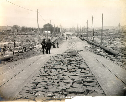 |
| Valencia St between 17th and 18th streets after the 1906 earthquake, looking north (Call Building on right in background.) photo: Source: San Francisco Historical Photograph Collection |
 |
| Map courtesy of Octoferret via Burrito Justice |
 |
| Looking south on Valencia Street at 20th Street. photo: San Francisco Historical Photograph Collection |
 |
| Source: San Francisco Historical Photograph Collection - photos of Valencia Street |
The streetcar was eventually abandoned in January 1949, during the heyday of the automobile and the dark ages of rail transit (or any transit for that matter).
After removing the streetcar tracks, the street was repaved. The sidewalks were also narrowed from 15 feet to 10 feet, although research by Eric Fischer indicates that it's unclear exactly when the sidwalks were narrowed.
The median is painted right on the asphalt. However, at intersections a small section of median is raised right next to the crosswalk.
 |
| Valencia Street (~1960) looking north at 14th Street towards the double-decker Central Freeway. photo: Eric Fischer |
 |
| Source: San Francisco Historical Photograph Collection - photos of Valencia Street |
Birth of Bike Lanes on Valencia: 1997 - 1999
The long lived median was removed in March 1997, along with median island traffic signals. Wide curb lanes created that act as de-facto bike lanes. However, a reader from Landscapes of Mobility and the Valencia Street Bicycle Lanes Report mention, the widened lane was "insufficient room to install bike lanes without removing traffic lanes. Configuration lasted until March 1999 when the street was re-striped as a three-lane street. Note that there is a similar situation happening right now on Folsom Street in the northeast Mission. Although not 4 lanes wide, the street has been narrowed to 3 lanes, but no bike lanes. However, the right hand lane is so wide (greater than 12 feet; probably 16 feet) that it's effectively an informal bike lane. Neither the late 90's Valencia, nor the early 10's Folsom have sharrows striped in.
 |
| Source: SFMTA (formerly DPT) Valencia Street Bicycle Lanes: A One Year Evaluation |
The Three Lane Years - 1999 - 2010
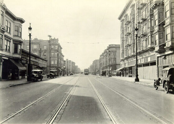
Valencia was converted to a three-lane street in March 1999. Traffic levels have stayed the same with half as many lanes. By having dedicated left turn lanes, traffic didn't get backed up as much as the left through lane in the 4-lane configuration. The same would likely happen on South Van Ness, Folsom and Guerrero. Example of the point is that parts of Folsom have recently been converted to a 3-lane configuration.
As shown in Eric Fischer's photo below, you can clearly see that the middle "turn" lane is significantly wider than the two travel lanes.
As shown in Eric Fischer's photo below, you can clearly see that the middle "turn" lane is significantly wider than the two travel lanes.
 |
| Valencia Street between 14th and 13th Streets, much like shown for the "Auto Years" photo above. Courtesy Eric Fischer |
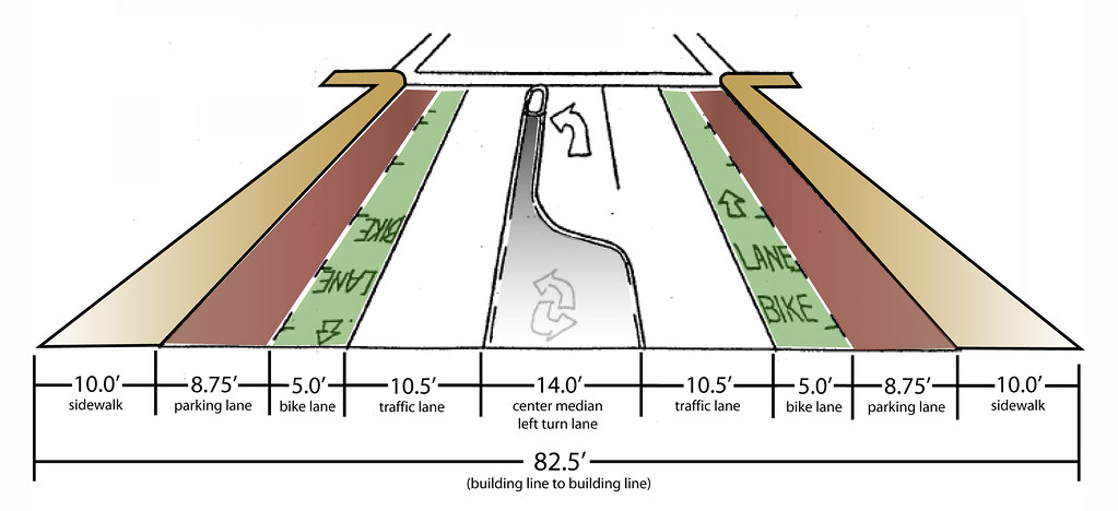 |
| Source: SFMTA Renewed Valencia Street Conceptual Master Plan (2006), and SFMTA (formerly DPT) Valencia Street Bicycle Lanes: A One Year Evaluation According to the 2000 report, the bike lanes were striped to 6 3/4 feet wide and parking lanes to 7 feet. The 2006 report dimensions are displayed in the diagram above. |
The Nueva Valencia Years: 2010 - present
The return of wider sidewalks!
Construction to began Summer 2009 on a major redesign of Valencia Street between 15th Street to 19th Street. The reconfiguration was completed in mid-2010.
Having a nearly 1 year construction period did take its toll on local businesses. I don't recall any businesses closing during construction, but Mariachi's did close later. In a Bay Citizen piece via the New York Times, Frjtz reported having barely survived. As you can see below, in the construction diagram, having a 5 foot sidewalk bounded by lots of construction makes going out to a restaurant less desirable.
 |
| Source: On site photographic estimates and the SFMTA A Renewed Valencia Street (2006) |
Luckily for those of us without businesses, we often forget the headaches of construction once the beautiful product is completed. Here's what Valencia Street turned into.
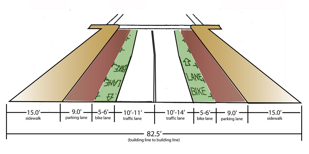
Street Configuration Changes
- Most blocks have a 5 foot wider sidewalks, especially in midblock sections
- Bike lanes have increased to 6 feet in the midblock, but only 5 1/2 feet or no gain at intersections
- Parking lanes have increased by 1/4 foot (3 inches). You can use every bit of space to separate opening doors and moving bicycles.
- Travel lanes varied from 10-14 feet instead of a uniform 10 1/2 feet.
Streetscape Changes
- Tree plantings
- Tree grates are specifically designed with a "Day of the Dead" theme.
- Bike parking
- Message poles
- New street lighting, most of which is oriented towards pedestrians, while still providing street lighting for moving vehicles.
- Corner bulbouts to shorten crosswalk distances
 |
| Source: SFMTA: Valencia, A Renewed Valencia Street, 2006 |
 |
| Photo courtesy sf.streetsblog and Matthew Roth |
Note that when the widths are added up on this, they have some extra room.
Configurations:
Midblock:
2x15' sidewalks, 2x9' parking lane, 2x6' bike lane, 2x11' travel lane = 82'
thus there's half a foot of wiggle room.
2x15' sidewalks, 2x9' parking lane, 2x6' bike lane, 2x11' travel lane = 82'
thus there's half a foot of wiggle room.
Corners without left turn pocket:
2x15' sidewalks, 2x9' parking lane, 2x5' bike lane, 1x10' travel lane, 1x14' travel lane including informal left turn = 82' thus there's half a foot of wiggle room.
2x15' sidewalks, 2x9' parking lane, 2x5' bike lane, 1x10' travel lane, 1x14' travel lane including informal left turn = 82' thus there's half a foot of wiggle room.
I'll have more later on the street reconfiguration - it's background, pros and cons, and how it's turned out.

i remember during the 3 lane era many times people would park in the center lane.
ReplyDeleteWas this EVER legal, or what? It seemed like enough people did it and either didn't get a ticket or didn't seem to mind getting one, but I never understood why people thought to do that in the first place.
Rather than waiting around for the two-lane segment to be extended, I'd love for the City to go ahead and restripe the remainder so the turn lane is a normal width (10'), thereby allowing for nice, wide (7') bike lanes with a greatly reduced risk of dooring.
ReplyDeleteGreg, parking in the middle was very likely never legal (except maybe on Sundays or hours of church services). I think you're dead on about people not mind getting a ticket. However I did see some cars get towed from time to time. Something that most of us DO MIND.
ReplyDeleteThe idea of repainting the remainder of the street with two lanes is great! We could even paint in a cycle track (with 7' lanes) as a test idea! You'd devote the remaining 5' on each side to a very wide buffer zone between parking and the bike lane. Right lanes would be added for turns so folks could see bikes before they turn.
Another piece of information: The plans for track removal on Valencia are dated February, 1952, and refer to the "existing parking lane" beyond the 10-foot sidewalk, so the sidewalk narrowing must have already happened prior to that date.
ReplyDeleteInteresting history. One important clarification: removal of the median in early 1990s did not create de facto bike lanes. Take a look at the lane width - the wide curb lane was just 12'. Nothing like the roomy comfort of today's Folsom street. It was truly awful to bike on Valencia as the lane was just wide enough for drivers to try and squeeze past. Change is good.
ReplyDeleteMary (of Landscapes of Mobility)
Good points Mary, it wasn't even close to being a bike lane in the late 90's. I've updated the post to reflect that it's wasn't really a defacto bike lane. I may need to revisit the wording.
ReplyDeleteI was hoping to find some photos of Valencia in the late 90's when the median was "removed" but still had 4 traffic lanes. Do you know where to find any?
Thanks for the history! I always wondered what happened to the cable cars on that street. I'd love to see them return. The J Church and 14 Mission aren't nearly as pleasant to ride (especially with the current detour of the 14 to Van Ness).
ReplyDeleteHaving streetcars or a, dare i say it, a modern cable car, return to the Mission or Castro/Noe Valley would seem to be nice. I agree that the J Church (unreliable) and the 14 Mission (congested at times and too far from Guerrero and a block from Valencia) are less convenient. Adding a streetcar line down Valencia or a cable car down Castro from Market to 24th Street would be possible. However, on Valencia, the streetcar would in fact be slow and be "stuck" in traffic with Valencia's two lane street. On Castro Street, a cable car did once climb the hill over to Noe Valley, but as we know, cable cars are quite noisy, require a powerhouse where the cables turn, require much more maintenance than streetcars, and go quite slow.
ReplyDeleteSo I believe that both would probably not prove to be good investments. However, if you had a creative solution there may be a way in there to get streetcars or cable cars into the Mission or Noe Valley. In my opinion, a trolleybus (electric bus) down Guerrero Street would be the best. At one point a bus or streetcar did go down Guerrero, but was removed. At an equidistance between the J Church and the 14 Mission (2 blocks) it would be an idea location for a line. The only issue would be garnering support from locals along Guerrero and proving ridership would be high enough to justify a rail investment.
Greg and B. Stokle,
ReplyDeleteParking in a middle median isn't legal at any time.
SFPD ticketed & towed cars which were parked there in the evening when folks from other parts of town come to Valencia for the restaurants, bars, entertainment.
However, a lot of people who have moved away from the Mission come back to their churches. Police ignored Sunday morning churchgoers' cars in the median.
At any rate, it's a double standard.
Since there is no longer a median in which to park it's a moot issue.
Without the center median to serve as a de facto parking lot, both restaurants and churches have been adversely affected.
One approach to improve bike safety is to place the bike lane close to sidewalk, separated from car traffic by a parking strip. It's simple and effective (and better for peds, too):
ReplyDeletehttp://www.nyc.gov/html/dot/downloads/pdf/201109_1st_2nd_aves_bicycle_paths_cb8.pdf