Forgotten Hills
22 May 2015
Forgotten Hills: Golden Gate Heights or Sunset Heights
Normally, a high and prominent peak it get's noticed. However, when it's a ridge, often shrouded in fog, and has two different names, you get confusion. On top of that, in San Francisco, it's a crowded field of peaks, so it's hard to get noticed if you don't have a monument, lavish homes or a radio tower on top. Welcome to Golden Gate Heights, err Sunset Heights - some of the highest peaks in San Francisco you never knew existed.
 In this installment of Forgotten Hills, we look at the Forest Hill-adjacent hill, that's really a ridge that has two competing names. The hills are less like Mark Twain/Samuel Clemmons, and more like Franklin W. Dixon/Carolyn Keene/Edward Stratemeyer of the the Hardy Boys and Nancy Drew book series. You probably barely know of the authors' existence, let alone the fact that the Hardy Boys and Nancy Drew series were originally written by the same man.
The name "Sunset Heights" dates back to the late 1880's when the company Easton, Eldridge and Co. marketed a block as "Sunset Heights" according to Lorri Ungaretti. Although Aurelius Buckingham and Sol Getz tried to claim credit, Ungaretti's book Stories in the Sand gives Easton Eldridge and Co. the credit. However, these 1880s "Sunset Heights" were what started the "Sunset" name for western San Francisco, but are not now considered the current Sunset Heights. In fact, they are considered part of the Haight Ashbury neighborhood.
I could not find any "history" on the name of Golden Gate Heights. I can only speculate that the area may have changed from Sunset to Golden Gate as a way to differentiate further that it is not the Sunset District.

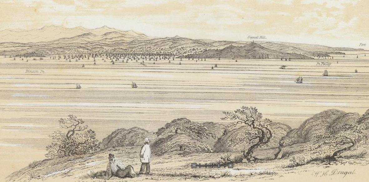
Image: OutsideLands.org
Name: Golden Gate Heights. Also known as Sunset Heights
Normally, a high and prominent peak it get's noticed. However, when it's a ridge, often shrouded in fog, and has two different names, you get confusion. On top of that, in San Francisco, it's a crowded field of peaks, so it's hard to get noticed if you don't have a monument, lavish homes or a radio tower on top. Welcome to Golden Gate Heights, err Sunset Heights - some of the highest peaks in San Francisco you never knew existed.
I could not find any "history" on the name of Golden Gate Heights. I can only speculate that the area may have changed from Sunset to Golden Gate as a way to differentiate further that it is not the Sunset District.

In this installment of Forgotten Hills, we look at the Forest Hill-adjacent hill, that's really a ridge that has two competing names. The hills are less like Mark Twain/Samuel Clemmons, and more like Franklin W. Dixon/Carolyn Keene/Edward Stratemeyer of the the Hardy Boys and Nancy Drew book series. You probably barely know of the authors' existence, let alone the fact that the Hardy Boys and Nancy Drew series were originally written by the same man.
The name "Sunset Heights" dates back to the late 1880's when the company Easton, Eldridge and Co. marketed a block as "Sunset Heights" according to Lorri Ungaretti. Although Aurelius Buckingham and Sol Getz tried to claim credit, Ungaretti's book Stories in the Sand gives Easton Eldridge and Co. the credit. However, these 1880s "Sunset Heights" were what started the "Sunset" name for western San Francisco, but are not now considered the current Sunset Heights. In fact, they are considered part of the Haight Ashbury neighborhood.
 |
| Image: OutsideLands.org |
Name: Golden Gate Heights. Also known as Sunset Heights
Height: 812 feet
Ridge/Hill Group: Sunset Heights - part of the central San Francisco "massif', which includes Mount Davidson, Twin Peaks, Mt. Sutro and Sunset Heights. The geographic heights include Forrest Hill.
Prominence: 312 feet (450 feet from west). Forest Hill is the 3rd most prominent peak in San Francisco.
Confusion: The names "Sunset Heights" and "Golden Gate Heights" seem to describe the same neighborhood and hills. Golden Gate Heights may be the high elevations of the neighborhood, while Sunset Heights is the greater neighborhood that includes the slopes leading from the "flats" of the Sunset District (both Inner and Outer Sunset).
Where: Western San Francisco, west of Twin Peaks and Mount Sutro, and South of Golden Gate Park.
Cross Streets: Between 7th and 16th avenues. South of Lawton St, and north of Taraval St.
Geography
Golden Gate Heights are a north-south ridge between Kirkham St to Taraval St. The ridge has four peaks, although the USGS map technically shows six peaks. To me, GG Heights is essentially a prominent and high ridge with three somewhat prominent peaks:
- Grand View Hill (666 feet)
- Larsen Peak (761 feet)
- Forest Hill (812 feet)
The heights lie due west of Twin Peaks and slightly southwest of Mt. Sutro and Clarendon Heights with the Midtown Terrace neighborhood and Laguna Honda ravine lying between them. To the east is the Sunset District gradually sloping down to the Pacific Ocean. The West Portal neighborhood to the south. To the north is the Inner Sunset neighborhood, with Golden Gate Park with Strawberry Hill a further north.
Note that geographically, the heights are one ridge - Golden Gate Heights. The neighborhoods of Forest Hill and Golden Gate Heights sit atop and on the slopes of the heights.


Name
As mentioned earlier, Sunset Heights as a name is first found in the 1880s. Naming of current Sunset Heights or Golden Gate Heights ridge is hard to find now. The neighborhood is called "Golden Gate Heights" in the real estate industry, and the park on the second highest peak has the same name. However, the neighborhood group is called Sunset Heights Association of Responsible People. I hope that is sufficiently confusing.
Even the peaks have naming confusion. Grand View Hill is sometimes called Turtle Hill, and has also been found misnamed as Larsen Peak. Larsen Peak is sometimes called Golden Gate Heights or Sunset Heights. Hawk Hill is not really a hill, but rather a steep slope of the southwest flank of Forest Hill. The only peak void of confusion is Forest Hill, the highest peak. Below is a breakdown of each peak, going from north to south.
Peak #1: Grand View Hill
Elevation: 666 feet
Alternate names: Turtle Hill, incorrectly named Larsen Peak
Coordinates: 37°45'22.32"N 122°28'18.60"W
Peak #2: Unnamed Hill (north)
Elevation: 750 feet
Alternate names: Cascade Hill (after the Cascade Walk steps)
Coordinates: 37°45'11.91"N 122°28'12.62"W (approximate)


View of Unnamed Hill (north) from Funston Ave (top two images)). View southwest to the Pacific Ocean at Aerial and Funston near Unnamed Hill (north). Images: Urban Life Signs
Peak #3: Unnamed Hill (south)
Elevation: 725 feet
Alternate names: Funston Court Hill (after Funston Street and the private court off the street), incorrectly named Larsen Peak
Coordinates: 37.751284°N, 122.469783°W (approximate)
Peak #4: Larsen Peak
Elevation: 761 feet
Alternate names: Golden Gate Heights Park Hill, Sunset Heights Park Hill, Golden Gate Heights, Sunset Heights
Coordinates: 37°44'59.8"N 122°28'10.9"W
Peak #5: Forest Hill
Elevation: 812 feet
Alternate names: none
Coordinates: 37.748240°N 122.467360°W (approximate)

The five peaks of Golden Gate Heights. Image: Urban Life Signs
Boundaries
Geographically speaking, defining the boundary of any "heights" or "valley" is actually a bit silly because there is not specific boundary. The only definite part of a heights, are its peaks and a ridge. The only definite part of a valley is it's flat or nearly flat parts that have very little slope. It's really the slopes that define the boundaries.
However, we're talking about a geographic feature AND a neighborhood. When confronted with the street grid imposed on a hilly area, we generally follow streets to define neighborhoods. Several sources have given Golden Gate Heights its boundaries:
Boundaries are described by northern edge, eastern edge, southern edge and western edge
7x7: (N) Kirkham St, (E) 8th Ave, (S) Rivera St, (W) 17th Ave.
SF Association of Realtors: (N) Lawton, (E) Funston-Noriega-11th Ave-Ortega-9th Ave-Mendosa-10th Ave, (S) San Marco-12th Ave-Taraval, (W) 14th Ave-Quintara-16th Ave
Golden Gate Heights Neighborhood Association: (N) Kirkham, (E) 9th Ave, (S) Santiago, (W) 19th Ave
Sunset Heights Association of Responsible People: (N) Lincoln, (E) Arguello, Warren Dr, 7th Ave & Laguna Honda Blvd, (S) Dewey Blvd and Taraval, (W) 19th Ave
History
The heights themselves seem to have been developed with streets in the 1920s. Most home construction occurred in the 1940s and 1950s.

Grand View Hill. Image: San Francisco Historical Center, sfpl.org

Golden Gate Heights aerial view (1948). North is to the right. Image: San Francisco Historical Center, sfpl.org
Height
The peaks of form a bit of a sloping ridge. Forest Hill rises the highest, up to 812 feet above sea level. The peak is topped by a water tower and a small radio and cellular tower. Several 20th Century condominiums are located at the deadend street of Mendosa Ave where the peak can be reached.


Nearby Larsen Peak is located in the wooded Golden Gate Heights Park. Rising 761 feet, it sometimes appears closer in height to Forest Hill due to the trees atop it. An unnamed peak is located further north on the ridge, rising to 750 feet, slightly lower than Larsen Peak.
Finally, Grand View Hill ends the ridge to the north. The peak is more prominent that you'd imagine and has a very recognizable peak covered in grass and a single tree.
Views and Prominence
The views from Golden Gate Heights quite stunning. Looking west to the Pacific, you feel as if you're perched above the ocean at 700 feet high, in spite of the 2 mile distance to the beach. To the north, Grand View Hill offers stunning views of much of San Francisco including Golden Gate Park, The Presidio, but also to Marin. I have yet to climb to the top of Grand View Hill, but am due to.
Due to the ridge nature of Golden Gate Heights, only the highest peak, Forest Hill has a higher degree of prominence at 312 feet. The three other peaks have very little official prominence:
- Golden Gate Heights - 750' elevation, 25' prominence
- Larsen Peak - 725' elevation, 25' prominence
- Golden Gate Heights Unnamed peak - 750' elevation, 12' prominence
- Grand View Hill - 666' elevation, 66' prominence.
However, if you figure in my version of "relative prominence, the Golden Gate Heights ridge overall has the following prominences from each direction:
- North: from the flats of the Inner Sunset and the manmade rolling lowlands of Golden Gate Park at ~225' elevation, Grand View Hill has a relative prominence of 441', while Larsen Peak has a relative prominence of 536'.
- East: Laguna Honda (Reservoir) at 371' elevation, GG Heights have a relative prominence of 441'.
- South: From the ravine of West Portal at 350' (where a creek once ran), Forest Hill's relative prominence is 462'.
- West: The Sunset District gradually slopes up from the Pacific Ocean all the way up to Golden Gate Heights, giving it a relative prominence of 812'. However, if you consider Sunset Reservoir (400') as the nearest western "peak" or "flat", then its relative prominence is only 412'.

View from Grand View Park. Image: Abe Kleinfeld
If you're interested in finding a more comprehensive list of San Francisco's hills I suggest going to SF Gazetteer, or to 47hills.com. SF Gazetteer is true to its word when it states "The most complete and accurate list of San Francisco hills." I am in a huge debt to all the work that SF Gazetteer did to compile its list of over 70 hills and the research on each of them. 47 Hills has a shorter list but many more photographs of the hills, or the view from them.v
Golden Gate Heights are a north-south ridge between Kirkham St to Taraval St. The ridge has four peaks, although the USGS map technically shows six peaks. To me, GG Heights is essentially a prominent and high ridge with three somewhat prominent peaks:
- Grand View Hill (666 feet)
- Larsen Peak (761 feet)
- Forest Hill (812 feet)
The heights lie due west of Twin Peaks and slightly southwest of Mt. Sutro and Clarendon Heights with the Midtown Terrace neighborhood and Laguna Honda ravine lying between them. To the east is the Sunset District gradually sloping down to the Pacific Ocean. The West Portal neighborhood to the south. To the north is the Inner Sunset neighborhood, with Golden Gate Park with Strawberry Hill a further north.
Note that geographically, the heights are one ridge - Golden Gate Heights. The neighborhoods of Forest Hill and Golden Gate Heights sit atop and on the slopes of the heights.
Note that geographically, the heights are one ridge - Golden Gate Heights. The neighborhoods of Forest Hill and Golden Gate Heights sit atop and on the slopes of the heights.


Name
As mentioned earlier, Sunset Heights as a name is first found in the 1880s. Naming of current Sunset Heights or Golden Gate Heights ridge is hard to find now. The neighborhood is called "Golden Gate Heights" in the real estate industry, and the park on the second highest peak has the same name. However, the neighborhood group is called Sunset Heights Association of Responsible People. I hope that is sufficiently confusing.
Even the peaks have naming confusion. Grand View Hill is sometimes called Turtle Hill, and has also been found misnamed as Larsen Peak. Larsen Peak is sometimes called Golden Gate Heights or Sunset Heights. Hawk Hill is not really a hill, but rather a steep slope of the southwest flank of Forest Hill. The only peak void of confusion is Forest Hill, the highest peak. Below is a breakdown of each peak, going from north to south.
Peak #1: Grand View Hill
Elevation: 666 feet
Alternate names: Turtle Hill, incorrectly named Larsen Peak
Coordinates: 37°45'22.32"N 122°28'18.60"W
Peak #2: Unnamed Hill (north)
Elevation: 750 feet
Alternate names: Cascade Hill (after the Cascade Walk steps)
Coordinates: 37°45'11.91"N 122°28'12.62"W (approximate)
Peak #3: Unnamed Hill (south)


 |
| View of Unnamed Hill (north) from Funston Ave (top two images)). View southwest to the Pacific Ocean at Aerial and Funston near Unnamed Hill (north). Images: Urban Life Signs |
Elevation: 725 feet
Alternate names: Funston Court Hill (after Funston Street and the private court off the street), incorrectly named Larsen Peak
Coordinates: 37.751284°N, 122.469783°W (approximate)
Peak #4: Larsen Peak
Elevation: 761 feet
Alternate names: Golden Gate Heights Park Hill, Sunset Heights Park Hill, Golden Gate Heights, Sunset Heights
Coordinates: 37°44'59.8"N 122°28'10.9"W
Peak #5: Forest Hill
Elevation: 812 feet
Alternate names: none
Coordinates: 37.748240°N 122.467360°W (approximate) |
| The five peaks of Golden Gate Heights. Image: Urban Life Signs |
Geographically speaking, defining the boundary of any "heights" or "valley" is actually a bit silly because there is not specific boundary. The only definite part of a heights, are its peaks and a ridge. The only definite part of a valley is it's flat or nearly flat parts that have very little slope. It's really the slopes that define the boundaries.
However, we're talking about a geographic feature AND a neighborhood. When confronted with the street grid imposed on a hilly area, we generally follow streets to define neighborhoods. Several sources have given Golden Gate Heights its boundaries:


Boundaries are described by northern edge, eastern edge, southern edge and western edge
7x7: (N) Kirkham St, (E) 8th Ave, (S) Rivera St, (W) 17th Ave.
SF Association of Realtors: (N) Lawton, (E) Funston-Noriega-11th Ave-Ortega-9th Ave-Mendosa-10th Ave, (S) San Marco-12th Ave-Taraval, (W) 14th Ave-Quintara-16th Ave
Golden Gate Heights Neighborhood Association: (N) Kirkham, (E) 9th Ave, (S) Santiago, (W) 19th Ave
Sunset Heights Association of Responsible People: (N) Lincoln, (E) Arguello, Warren Dr, 7th Ave & Laguna Honda Blvd, (S) Dewey Blvd and Taraval, (W) 19th Ave
Sunset Heights Association of Responsible People: (N) Lincoln, (E) Arguello, Warren Dr, 7th Ave & Laguna Honda Blvd, (S) Dewey Blvd and Taraval, (W) 19th Ave
History
The heights themselves seem to have been developed with streets in the 1920s. Most home construction occurred in the 1940s and 1950s.
|
| Grand View Hill. Image: San Francisco Historical Center, sfpl.org |
 |
| Golden Gate Heights aerial view (1948). North is to the right. Image: San Francisco Historical Center, sfpl.org |
Height
The peaks of form a bit of a sloping ridge. Forest Hill rises the highest, up to 812 feet above sea level. The peak is topped by a water tower and a small radio and cellular tower. Several 20th Century condominiums are located at the deadend street of Mendosa Ave where the peak can be reached.


Nearby Larsen Peak is located in the wooded Golden Gate Heights Park. Rising 761 feet, it sometimes appears closer in height to Forest Hill due to the trees atop it. An unnamed peak is located further north on the ridge, rising to 750 feet, slightly lower than Larsen Peak.
Finally, Grand View Hill ends the ridge to the north. The peak is more prominent that you'd imagine and has a very recognizable peak covered in grass and a single tree.
Views and Prominence
The views from Golden Gate Heights quite stunning. Looking west to the Pacific, you feel as if you're perched above the ocean at 700 feet high, in spite of the 2 mile distance to the beach. To the north, Grand View Hill offers stunning views of much of San Francisco including Golden Gate Park, The Presidio, but also to Marin. I have yet to climb to the top of Grand View Hill, but am due to.
Due to the ridge nature of Golden Gate Heights, only the highest peak, Forest Hill has a higher degree of prominence at 312 feet. The three other peaks have very little official prominence:
- Golden Gate Heights - 750' elevation, 25' prominence
- Larsen Peak - 725' elevation, 25' prominence
- Golden Gate Heights Unnamed peak - 750' elevation, 12' prominence
- Grand View Hill - 666' elevation, 66' prominence.
However, if you figure in my version of "relative prominence, the Golden Gate Heights ridge overall has the following prominences from each direction:
- North: from the flats of the Inner Sunset and the manmade rolling lowlands of Golden Gate Park at ~225' elevation, Grand View Hill has a relative prominence of 441', while Larsen Peak has a relative prominence of 536'.
- East: Laguna Honda (Reservoir) at 371' elevation, GG Heights have a relative prominence of 441'.
- South: From the ravine of West Portal at 350' (where a creek once ran), Forest Hill's relative prominence is 462'.
- West: The Sunset District gradually slopes up from the Pacific Ocean all the way up to Golden Gate Heights, giving it a relative prominence of 812'. However, if you consider Sunset Reservoir (400') as the nearest western "peak" or "flat", then its relative prominence is only 412'.
 |
| View from Grand View Park. Image: Abe Kleinfeld |
If you're interested in finding a more comprehensive list of San Francisco's hills I suggest going to SF Gazetteer, or to 47hills.com. SF Gazetteer is true to its word when it states "The most complete and accurate list of San Francisco hills." I am in a huge debt to all the work that SF Gazetteer did to compile its list of over 70 hills and the research on each of them. 47 Hills has a shorter list but many more photographs of the hills, or the view from them.v
29 March 2013
Forgotten Hills: La Portezuela
A 450-foot high hill would seem to draw some attention, especially when it rises 200 feet above a BART station, and 450 feet above Lake Merced. Alas, it only rises 50 feet above Mission Street in Daly City at Top of the Hill. A hill that straddles the boundary with Daly City doesn’t get much love. In the latest installment of Forgotten Hills, we look at La Portezuela in southwest San Francisco right on the border with Daly City.
 |
| La Portezuela's north side seen from Head Street in Ingleside Heights. |
 |
| View of La Portezuela from the Daly City BART parking garage. Reservoir Hill is to the right. Mission Street and Daly City's Top of the Hill district are between the hills |
 |
| View looking north and east from La Portezuela. Merced Heights are near left, while Mount Davidson is the highpoint (center). Downtown Oakland can be seen in the distance (right). |
Geography
The hill in question rises high above Lake Merced and the Brotherhood Way ravine, while looking across at Merced Heights to the north and Fort Funston to the west. The hill climbs to an elevation of 450 feet and lies at the top of Bepler Street, a modest residential street in Daly City. Despite its height, the hill may have no official name. There are many names for a historic hill once called La Portezuela in Daly City but I the location of the historic hill is not specified precisely.

As shown in the map above, the hill is virtually the southernmost peak in San Francisco. Although the slopes of The Saddle (a hill in San Bruno Mountain State Park) rise nearly 50 feet higher than La Portezuela, the peak likes south of the San Francisco city limit.
More maps, images and descriptions after the break.
More maps, images and descriptions after the break.
 |
| At 450', La Portezuela is only 50 feet lower than Merced Heights highest peak |
 |
| Mission Street passes through the saddle between La Portezuela and Resevoir Peak to the southeast. |
Name
What is the name of this hill at the end of Bepler Street? The e-book, Gateway to the Peninsula: A History of the City of Daly City by Samuel Chandler references a hill or place in this general area. Its was first known as “La Portezuela”.
…the priests from the Mission and the soldiers from the Presidio had marked out a winding trail that connected San Francisco to the rest of California. At the place where the road reached the top of Mission Hill (not sure where this is) the priests noted a gap between San Bruno Mountain and the Coastside Hills and named it La Portezuela. It has since been known by other names, notably Daly's Hill, the Top of the Hill, and the Center of Daly City.
Whether or not the physical name describes the saddle along Mission Street between Reservoir Hill and the hill OR the actual hill we’re studying here, we’re naming the hill La Portezuela. We could have called it Daly’s Hill, Top of the Hill, or even Bepler Street Hill, Boundary Hill, Porto Suelo Butte or Hillcrest Hill, but La Portezuela seemed the most historic and romantic name. La Portezuela means "The Little Door" in Spanish. Maybe this hill is the little door between San Francisco and Daly City.
 |
| Bepler Street, showing the south face of the hill which only descends 50 feet to Mission Street. |
Name: La Portezuela
Height: 450 feet
Ridge/Hill Group: San Bruno Mountain
Prominence: 50 feet (but 450 feet to northwest).
Reservoir Peak is the nearest peak (southeast of La Portezuela) and reduces the hill’s prominence with its 775 foot height.
Reservoir Peak is the nearest peak (southeast of La Portezuela) and reduces the hill’s prominence with its 775 foot height.
Confusion: Lacks a specific name. However the hill mentioned in Gateway to the Peninsula may be this hill.
Where: At the San Francisco/Daly City city limit just northeast of the Top of the Hill shopping district
Cross Streets: At the top of Bepler street just northwest of the intersection with Rhine Street.
 |
| 1869 US Coastal Survey Map. Image: David Rumsey Collection |
 | |
|
History
There’s not much history of this site, apart from what I’ve already mentioned. The hill rises above the first community of Daly City and it appears that the Spring Valley Water Company owned the top of the hill originally and had a water tower or reservoir on the peak at one time (as shown in the August Chevalier map below (1911)). In addition, the block of Bepler Street at the top of the hill appears to have been developed between the 1940s and 1990s.
 |
| Chevalier Map of San Francisco (1911). Image David Rumsey Collection |
 |
| Aerial Image of Daly City (1937). Image: David Rumsey Collection |
Height
Regarding the hill's precise height, the only source is USGS maps which show it being more than 450 feet high, but below 475 feet.
The hill is seen in many U.S. Coastal Surveys maps, but no height specific height is indicated.
 |
| Birdseye view looking east. Daly City BART (bottom) and La Portezuela (top). Image: Bing Maps |
 |
| View of La Portezuela from I-280. Image: Google Maps |
Views and Prominence
The previous two hills we looked at, Hunters Point Hill and Black Point at Fort Mason, had low elevations of 125 and 111 feet respectively.
What makes La Portezuela hill noteworthy is its steepness to the north overlooking the Brotherhood Way ravine. It's so steep that the Bepler Street does not pass through north of the hill, nor does Head Street rise up the hill from the north. By being on the border between San Francisco and Daly City, this makes it a duel city peak. The peak itself may reside in Daly City or San Francisco. I could not ascertain where the precise border was. The pavement on the street does change, However, I don’t know if this is due to each city paving differently (like at a state border), or that the end of the street might be designated a private street.
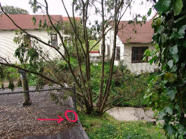
 |
| View of the actual peak, which is not at the exact end of the street. Note the change from dark to light street pavement (right center). |
The view from the top of the hill is most striking feature. A narrow vista looks northwest to the Marin Headlands and Point Reyes. A grand vista (as shown in the first image up top) affords a wide view from Sunset Heights to Mt. Davidson, to Excelsior with parts of Oakland showing through and Mt. Diablo (which is visible from almost anywhere of any moderate elevation).
 |
| Park Merced Apartments with Point Reyes in the distance on this clear day. |
 |
| Excelsior is in the midground while Downtown Oakland is to the left in the background. |
 |
| View of Sutro Tower and Mt. Davidson |
 |
| View southeast to San Bruno Mountain and its radio towers. The homes are atop the flanks of Reservoir Hill in Daly City. |
If you're interested in finding a more comprehensive list of San Francisco's hills I suggest going to SF Gazetteer, or to47hills.com. SF Gazetteer is true to its word when it states "The most complete and accurate list of San Francisco hills." I am in a huge debt to all the work that SF Gazetteer did to compile its list of over 70 hills and the research on each of them. 47 Hills has a shorter list but many more photographs of the hills, or the view from them.
28 January 2013
Forgotten Hills: Fort Mason's Black Point
The high mountains and steep hills get all of the attention. What about the shorter hills with history and character? What about the strategic hills that historically protected the bay with cannons 100 feet above the bay. In the latest installment of Forgotten Hills, we look at Black Point at Fort Mason.
As shown in the map above, the hill at Fort Mason may even be the northernmost peak on mainland San Francisco. Although the ridge leading to Fort Point is higher, it doesn't have an outright peak that is further north than the Fort Mason Hill. Of course Alcatraz's high point and Goat Hill on Yerba Buena Island are further north but on islands.
Name: Black Point
 |
| Looking west to Golden Gate from Black Point batteries. A Civil War battery in foreground with Fort Mason Center wharves to right. |
 |
| Fort Mason's hill is covered in trees. In the center middle ground is one of the Fort Mason Wharves. Golden Gate Bridge and Marin are in the background while Aquatic Park is in the foreground. |
UPDATE: Find about about other Forgotten Hills. Hunters Point Hill, and La Portezuela
Geography
The hill in question rises as a bluff above Black Point looking over San Francisco Bay at the northern edge of Fort Mason. Lying to the west of Aquatic Park, and east of Marina Green, the hill rises 111 feet above what is possibly the last original and untouched San Francisco coastline on the bay. Despite having modest defenses installed during Spanish times when it was called Point San Jose, or later during the American Civil War when batteries of cannons were installed at the Post at Point San Jose, the hill does not seem to have an official name. |
| Location of hill at Black Point in Fort Mason. |
 |
| Topographic surrounding of Black Point, aka Fort Mason Bluff |
 |
| Fort Mason Bluff (aka Black Point) at 111' is overshadowed by Russian Hill's 302' peak nearby. |
Name
Is the hill simply Black Point? Black Point is the name of the land formation protruding into San Francisco Bay, much like Fort Point, or Point Lobos – not the hill itself. Or do we call the hill the more mundane Fort Mason Hill? What about Fort Mason Bluff? For our purposes, we'll just call this 111 foot forgotten hill Black Point.
Ridge/Hill Group: Nob/Russian Hills
Height: 111 feet
Confusion: Lacks a specific name. The point into the bay is not technically the hill.
Where: Fort Mason in the Golden Gate National Recreation Area at the Black Point Battery
Cross Streets: just north of the intersection of Franklin St and Funston St


Height
Regarding height, the only referenced "official" height is 111 feet from Geocashing.com. A benchmark is placed on the top of the Burnham Battery by the National Geodetic Survey.
The hill has been measured over several U.S. Coastal Surveys with either no height mentioned or several different heights: 116' (1868 Map of Point San Jose), 115' (1926 survey), and the current 111 feet.
Views and Prominence
As mentioned in the Hunters Point Hill post, there are few hills at this low height. Only Rincon Hill (105'), Alice Griffith Hill (75') and Irish Hill (50') are shorter, with Hunters Point Hill rising higher to 125 feet.
What makes these hills noteworthy is their proximity to the bay, especially Black Point with its steep bluff overlooking the bay. As you can see in some of the photos, the hill does not stand out as dramatically as others. However views from the top of the hill show the steepness of the hill and the dramatic views of Alcatraz Island and overlooking the bay.
Thank you to Amy Hoke and Craig Scott at Fort Mason for their help in researching the history and height of Black Point. If you're interested in finding a more comprehensive list of San Francisco's hills I suggest going to SF Gazetteer, or to 47hills.com. SF Gazetteer is true to its word when it states "The most complete and accurate list of San Francisco hills." Incidentally, both Black Point and Hunters Point Hill are not on the SF Gazetteer's "How Many Hills are there in San Francisco?" list. That said, I am in a huge debt to all the work that SF Gazetteer did to compile its list of over 70 hills and the research on each of them. 47 Hills has a shorter list but many more photographs of the hills, or the view from them.
Height: 111 feet
Confusion: Lacks a specific name. The point into the bay is not technically the hill.
Where: Fort Mason in the Golden Gate National Recreation Area at the Black Point Battery
Cross Streets: just north of the intersection of Franklin St and Funston St
 |
| Fort Mason in 1905, soon after Battery Burnham (grey half circle center top) was installed. Image: National Park Service, Cultural Landscape Report for Fort Mason |
 |
| Fort Mason in 2003, which is virtually unchanged ten years later. The high point at Battery Burnham is covered in brush but still marked in grey. Image: National Park Service, Cultural Landscape Report for Fort Mason |
 |
| Black Point. Image: 1869 U.S. Coastal Survey via David Rumsey |
History
Prior to European settlement, the Yelamu Ohlone lived seasonally at this peninsula on San Francisco Bay. After Spanish settlement of San Francisco, the Spanish installed a secondary defense (to support the Presidio's primary defense) at Punta Medanos, or "Point Sand Dune". Thus began the Bateria San José – the future Fort Mason.

The name Black Point comes from the dark laurel brush on the east side of the bluff, facing modern day Aquatic Park. As shown in the illustration below, the point is one of four promontories that originally jutted north into San Francisco Bay. From east to west (background to foreground in the image) Fort Point marked the entrance to the bay at the Strait of Golden Gate. Black Point was the second line of defense, whose battery complimented Alacatraz's battery. Russian Hill dropped steeply into the bay, and Telegraph Hill (originally Signal Hill) was the final hill on the bay before the turn to Yerba Buena Cove where the city started.
The high point of the hill is actually where the last battery was built at Fort Mason. The Cultural Landscape Report for Fort Mason notes that the Endicott system batteries were the forts lasts gun emplacements,
"By 1899, only after improvements to higher priority gun positions were well advanced around the bay, was work initiated at Fort Mason on Battery Burnham, located above and to the rear of the earlier earthen Civil War batteries. Atop Battery Burnham was a single 8-inch breech-loading rifle, mounted on a disappearing carriage designed to rotate below the concrete parapet for protection and convenient loading. The battery was armed and operational by early 1900. The construction of Battery Burnham at the topographic summit of Point San Jose required the relocation of the post flagpole from its prominent spot there to a location just to the rear of the new battery at the head of Sheridan Street. Battery Burnham constituted the third system of coastal fortification built at Point San Jose since 1797, when the Spanish fashioned Bateria Yerba Buena out of bundled sticks and piled sand." (Page 59)
After the 1906 earthquake, much of the fort was used for displaced San Franciscans. In the rebuilding of the city, most of the activity at Fort Mason transferred to its lower area, on the northwest shore where the Fort Mason Center is now located. Several new wharves and warehouses were built here and used heavily during WWI, WWII and the Korean War as the Port of Embarkation for war personnel and supplies. The fort was transferred to the National Park Service in 1972. Since 1906, Upper Fort Mason, its hilltop and the Burnham Battery have been largely unmodified.

Height
Regarding height, the only referenced "official" height is 111 feet from Geocashing.com. A benchmark is placed on the top of the Burnham Battery by the National Geodetic Survey.
The hill has been measured over several U.S. Coastal Surveys with either no height mentioned or several different heights: 116' (1868 Map of Point San Jose), 115' (1926 survey), and the current 111 feet.
 |
| Map of San Francisco Bay depths from 1926 U.S. Coastal Survey map "San Francisco Entrance, California" |
 |
| National Geodetic Survey benchmark marking high point at Fort Mason. Image: Geocashing.com, User: Rocky Road and Annie |
 |
| Location of high point on battery roof. Image: Geocashing.com, User: cjf |
 |
| View of Burnham Battery roof with Pacific Heights and Sutro Tower in the background. |
Views and Prominence
As mentioned in the Hunters Point Hill post, there are few hills at this low height. Only Rincon Hill (105'), Alice Griffith Hill (75') and Irish Hill (50') are shorter, with Hunters Point Hill rising higher to 125 feet.
What makes these hills noteworthy is their proximity to the bay, especially Black Point with its steep bluff overlooking the bay. As you can see in some of the photos, the hill does not stand out as dramatically as others. However views from the top of the hill show the steepness of the hill and the dramatic views of Alcatraz Island and overlooking the bay.
 |
| View from the top of Black Point, overlooking the Municipal Pier at Aquatic Park, with Alcatraz and Angel Island in the distance. |
 |
| Looking east to Fort Mason and Black Point from Marina Green |
 |
| View of Aquatic Park Cove and Hyde Street Pier at Fishermans Wharf from Black Point. Haskell House is to the left. |
 |
| Aerial view looking southeast to Fort Mason Center and Fort Mason. Note the brown bluff leading up to the hill. Image: FortMason.org |
28 December 2012
Forgotten Hills: Hunters Point Hill
San Francisco is famous for its hills. However, out of the dozens of hills, small and large, high and low, some have been forgotten or ignored. Some of these hills have yet to be named. Some hills have some sort of name, however, they aren't part of the cities general knowledge. This time we look at San Francisco's easternmost hill: Hunters Point Hill.
Name: Hunters Point Hill
Height: 125 feet
Ridge/Hill Group: Hunters Point Ridge
Prominence: 25 feet
Original Height of 171 feet had a 50 foot prominence and a 171 foot prominence to the east.
Confusion: often confused with Stony Hill, which is the high point of the ridge at 282 feet.
Where: The Shipyard Development (Former Hunters Point Naval Station)
Cross Streets: Jerrold Ave and Coleman St
UPDATE: Find about about other Forgotten Hills. Black Point at Fort Mason, and La Portezuela
Hunters Point Hill is one of San Francisco's lowest hills at 125 feet according to US Geological Survey (USGS) maps. Only Rincon Hill (105'), Fort Mason Bluff (100'), Alice Griffith Hill (75') and Irish Hill (50') are shorter. Much like Rincon and Irish, it appears to be one of the most carved out hills, as shown by the Google StreetView image below. The rather modest peak is to the right the right of the blocked off street (Innes St).
Many folks may have forgotten about the hill for several reasons. For decades it resided in an off-limits naval base. Also, rising a modest 125 feet, or by some counts, only 106 feet, the hill isn't quite the promontory of a Telegraph Hill or the dominating height of Twin Peaks. The main reason is that it is overshadowed by its higher neighbor, Stony Hill (282') and Mt. St. Joseph (250') (Silver Terrace). These two are much higher, and are in areas much more frequented by people.
As shown on the map below, you can see that Hunters Point Hill lies on the east end of the Hunters Point Ridge, rising about 50 feet above the saddle in the ridge separating it from Stony Hill and the higher parts of Hunters Point Ridge. It's one claim to a superlative is the fact the hill is the easternmost hill on the San Francisco mainland. (Goat Hill (338') on Yerba Buena Island lies slightly further east.)
In the past, there were actually two peaks on the eastern end of Hunters Point. As shown in the US Coastal Survey Map (via the David Rumsey Collection), you can see one distinct peak rising to 171 feet, and two modest peaks rising to 150 feet next to the word "Point" in "Hunters Point". The 171 foot peak has clearly been excavated to make landfill for the Hunters Point Naval Shipyard. However the more modest peak remains, however excavated a more modest 25 feet down to its current 125 feet.
The current peak is near the two yellow topo lines. The original peak is marked with the yellow arrow and the 171' marker.
Plans for the Hunters Point Redevelopment call for the hill to be remade with dense housing and several parks, including Hunters View Park.
As shown in the image below, the high point of this hill is in the upper left, near the intersection of Coleman St and Jerrold Ave, which is at the far left intersection as highlighted by the image below.
Meanwhile the area is still quite desolate, which was accentuated by the rainy day when I visited the hill. Luckily renderings of the future development, and a video by The Shipyard show nicer images of today and the future. See below.

Images from The Shipyard video on art.
Note that information on San Francisco's hills, their names and heights can be found at many different web sites. The names of hills, location, and height are not consistent. In other words, a hill like Bernal Peak has more than several heights listed. Bernalwood, did a piece on this that explains the many challenges to finding a peaks actual height in a piece called "How Tall is Bernal Hill, Really?"
You can also find a great list at SF Gazetteer and an alternative list with great photographs at 47 Hills.
Name: Hunters Point Hill
Height: 125 feet
Ridge/Hill Group: Hunters Point Ridge
Prominence: 25 feet
Original Height of 171 feet had a 50 foot prominence and a 171 foot prominence to the east.
Confusion: often confused with Stony Hill, which is the high point of the ridge at 282 feet.
Where: The Shipyard Development (Former Hunters Point Naval Station)
Cross Streets: Jerrold Ave and Coleman St
UPDATE: Find about about other Forgotten Hills. Black Point at Fort Mason, and La Portezuela
 |
| Hunters Point Hill seen from Donohue and Jerrold streets. Friedell Street is in the foreground with Jerrold crossing the hill. |
 |
| Photo: Google Maps |
As shown on the map below, you can see that Hunters Point Hill lies on the east end of the Hunters Point Ridge, rising about 50 feet above the saddle in the ridge separating it from Stony Hill and the higher parts of Hunters Point Ridge. It's one claim to a superlative is the fact the hill is the easternmost hill on the San Francisco mainland. (Goat Hill (338') on Yerba Buena Island lies slightly further east.)
 |
| Hunters Point Hill in southeastern San Francisco on the Hunters Point peninsula. |
 |
| Hunters Point Ridge and local topgraphy. Source: San Francisco Topography Map |
In the past, there were actually two peaks on the eastern end of Hunters Point. As shown in the US Coastal Survey Map (via the David Rumsey Collection), you can see one distinct peak rising to 171 feet, and two modest peaks rising to 150 feet next to the word "Point" in "Hunters Point". The 171 foot peak has clearly been excavated to make landfill for the Hunters Point Naval Shipyard. However the more modest peak remains, however excavated a more modest 25 feet down to its current 125 feet.
The current peak is near the two yellow topo lines. The original peak is marked with the yellow arrow and the 171' marker.
 |
| 1907 US Coastal Survey. Source: David Rumsey Collection |
 |
| Shipyard Development. This cross street is near the high point of the hill. Image: San Francisco Redevelopment Agency |
 |
| Image: TheShipyardSF.com |
 |
| Image: TheShipyardSF.com |

 |
| Image: TheShipyardSF.com |
 |
| Source: The Shipyard: Renovating a Community Through Art |
 |
| Source: The Shipyard: Renovating a Community Through Art |
 |
| Source: The Shipyard: Renovating a Community Through Art |
You can also find a great list at SF Gazetteer and an alternative list with great photographs at 47 Hills.

Comments
Post a Comment