The high mountains and steep hills get all of the attention. What about the shorter hills with history and character? What about the
hills that historically protected the bay with cannons 100 feet above the bay. In the latest installment of
.
The hill in question rises as a bluff above Black Point looking over San Francisco Bay at the northern edge of Fort Mason. Lying to the west of Aquatic Park, and east of Marina Green, the hill rises 111 feet above what is possibly the last original and untouched San Francisco coastline on the bay. Despite having modest defenses installed during Spanish times when it was called Point San Jose, or later during the American Civil War when batteries of cannons were installed at the
, the hill does not seem to have an official name.
As shown in the map above, the hill at Fort Mason may even be the northernmost peak on mainland San Francisco. Although the ridge leading to Fort Point is higher, it doesn't have an outright peak that is further north than the Fort Mason Hill. Of course Alcatraz's high point and Goat Hill on Yerba Buena Island are further north but on islands.
Is the hill simply Black Point? Black Point is the name of the land formation protruding into San Francisco Bay, much like Fort Point, or Point Lobos – not the hill itself. Or do we call the hill the more mundane Fort Mason Hill? What about Fort Mason Bluff? For our purposes, we'll just call this 111 foot forgotten hill Black Point.
Height: 111 feet
Ridge/Hill Group: Nob/Russian Hills
Prominence: 23 feet (but 111 feet from north, east and west)
Confusion: Lacks a specific name. The point into the bay is not technically the hill.
Where: Fort Mason in the
Golden Gate National Recreation Area at the Black Point Battery
Cross Streets: just north of the intersection of Franklin St and Funston St
 |
Fort Mason in 1905, soon after Battery Burnham (grey half circle center top) was installed.
Image: National Park Service, Cultural Landscape Report for Fort Mason |
 |
Fort Mason in 2003, which is virtually unchanged ten years later. The high point at Battery Burnham is covered in brush but still marked in grey.
Image: National Park Service, Cultural Landscape Report for Fort Mason |
 |
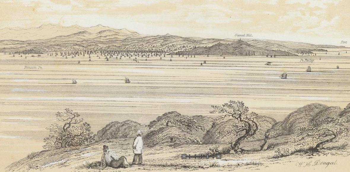
| Black Point. Image: 1869 U.S. Coastal Survey via David Rumsey |
History
Prior to European settlement, the Yelamu Ohlone lived seasonally at this peninsula on San Francisco Bay. After Spanish settlement of San Francisco, the Spanish installed a secondary defense (to support the Presidio's primary defense) at Punta Medanos, or "Point Sand Dune". Thus began the Bateria San José – the future Fort Mason.
The name Black Point comes from the dark laurel brush on the east side of the bluff, facing modern day Aquatic Park. As shown in the illustration below, the point is one of four promontories that originally jutted north into San Francisco Bay. From east to west (background to foreground in the image) Fort Point marked the entrance to the bay at the Strait of Golden Gate. Black Point was the second line of defense, whose battery complimented Alacatraz's battery. Russian Hill dropped steeply into the bay, and Telegraph Hill (originally Signal Hill) was the final hill on the bay before the turn to Yerba Buena Cove where the city started.
The high point of the hill is actually where the last battery was built at Fort Mason. The
Cultural Landscape Report for Fort Mason notes that the Endicott system batteries were the forts lasts gun emplacements,
"By 1899, only after improvements to higher priority gun positions were well advanced around the bay, was work initiated at Fort Mason on Battery Burnham, located above and to the rear of the earlier earthen Civil War batteries. Atop Battery Burnham was a single 8-inch breech-loading rifle, mounted on a disappearing carriage designed to rotate below the concrete parapet for protection and convenient loading. The battery was armed and operational by early 1900. The construction of Battery Burnham at the topographic summit of Point San Jose required the relocation of the post flagpole from its prominent spot there to a location just to the rear of the new battery at the head of Sheridan Street. Battery Burnham constituted the third system of coastal fortification built at Point San Jose since 1797, when the Spanish fashioned Bateria Yerba Buena out of bundled sticks and piled sand." (Page 59)
After the 1906 earthquake, much of the
fort was used for displaced San Franciscans. In the rebuilding of the city, most of the activity at Fort Mason transferred to its lower area, on the northwest shore where the Fort Mason Center is now located. Several new wharves and warehouses were built here and used heavily during WWI, WWII and the Korean War as the Port of Embarkation for war personnel and supplies. The fort was transferred to the National Park Service in 1972. Since 1906, Upper Fort Mason, its hilltop and the Burnham Battery have been largely unmodified.
Regarding height, the only referenced "official" height is 111 feet from
Geocashing.com. A benchmark is placed on the top of the Burnham Battery by the National Geodetic Survey.
The hill has been measured over several U.S. Coastal Surveys with either no height mentioned or several different heights: 116' (1868 Map of Point San Jose), 115' (
1926 survey), and the current 111 feet.
 |
| Map of San Francisco Bay depths from 1926 U.S. Coastal Survey map "San Francisco Entrance, California" |
 |
National Geodetic Survey benchmark marking high point at Fort Mason.
Image: Geocashing.com, User: Rocky Road and Annie |
 |
| Location of high point on battery roof. Image: Geocashing.com, User: cjf |
 |
| View of Burnham Battery roof with Pacific Heights and Sutro Tower in the background. |
Views and Prominence
As mentioned in the
Hunters Point Hill post, there are few hills at this low height. Only Rincon Hill (105'), Alice Griffith Hill (75') and
Irish Hill (50') are shorter, with Hunters Point Hill rising higher to 125 feet.
What makes these hills noteworthy is their proximity to the bay, especially Black Point with its steep bluff overlooking the bay. As you can see in some of the photos, the hill does not stand out as dramatically as others. However views from the top of the hill show the steepness of the hill and the dramatic views of Alcatraz Island and overlooking the bay.
 |
| View from the top of Black Point, overlooking the Municipal Pier at Aquatic Park, with Alcatraz and Angel Island in the distance. |
 |
| Looking east to Fort Mason and Black Point from Marina Green |
 |
| View of Aquatic Park Cove and Hyde Street Pier at Fishermans Wharf from Black Point. Haskell House is to the left. |
 |
| Aerial view looking southeast to Fort Mason Center and Fort Mason. Note the brown bluff leading up to the hill. Image: FortMason.org |
Thank you to Amy Hoke and Craig Scott at Fort Mason for their help in researching the history and height of Black Point. If you're interested in finding a more comprehensive list of San Francisco's hills I suggest going to
SF Gazetteer, or to
47hills.com. SF Gazetteer is true to its word when it states "The most complete and accurate list of San Francisco hills." Incidentally, both Black Point and Hunters Point Hill are not on the SF Gazetteer's "How Many Hills are there in San Francisco?" list. That said, I am in a huge debt to all the work that SF Gazetteer did to compile its list of over 70 hills and the research on each of them. 47 Hills has a shorter list but many more photographs of the hills, or the view from them.


I love this forgotten hill and am happy to learn the (probable) name. I'm a fan of historic large artillery (read: old cannons) and the one here is one of my favorites outside of the Presidio.
ReplyDeleteI look forward to thinking about this great post on my next bike ride up and down all 111' feet of this. I just noticed that someone complained about this hill on their Yelp review of the hostel there. Ha!
@SuedeShirtCalif made some good comments via Twitter regarding the early history of Fort Mason, regarding squatters and Fremont's wife who lived there as a squatter.
ReplyDeleteThe de-Twitter comments are below:
@urbanlifesigns Re[garding] Black Pt [you made] no mention [of the] neglected Federal military reservation from 1850-63 [when] squatters (including the Fremonts) [lived on the site, but were later evicted.]
He also mention's Broderick's death and Haskell House. Haskell House was home to Leonid Haskell, a major on General Fremont's staff from the 1850s until he was evicted in the 1860s when the Army evicted all squatters. FoundSF has a good summary on the house. http://foundsf.org/index.php?title=Haskell_House
U.S. Senator of California, David Broderick, died in Haskell House after a duel at Lake Merced with Justice David Terry in 1879. Senator Broderick was California's 4th U.S. Senator. You can read more about the duel here: http://www.hmdb.org/marker.asp?marker=18295
Nice article, Brian.
ReplyDeleteWhen I read it I wondered why I hadn't included Black Point on my list. I just looked back at my longer candidate list, which did include Black Point, and realized that I eliminated it because it didn't (as best I could tell from USGS maps) meet the criteria I'd set of being separated from neighboring elevations by a 50-or-more-feet-deep valley. On the Bay side Black Point is an impressive elevation; on the land side it's not a distinct feature at all. I gave a few hills on my list some slack because they were traditionally named hills, but that's not the case with Black Point's hill.
There are probably spots on the city's west coast that I eliminated for the same reason. Inland hills have gotten most of the attention in the literature, and that shaped my criteria; maybe bluffs should be considered differently.
Cheers!
Dave,
DeleteYou're absolutely right that the hill at Black Point doesn't dip 50 feet to the southeast. It's essentially a sub-hill of Russian HIll by your 50 feet criteria. At least it rises 25 feet above its surroundings in all directions. Because of it's dramatic bay side (and even east side) slope, I still think it's a hill.
You may be on to something about bluffs. That would make Hawk Hill happy since it's really just a bluff.
This photo from 1865 also seems to be from Black Point Cove looking west towards the point:
ReplyDeletehttp://www.getty.edu/art/gettyguide/artObjectDetails?artobj=88840