Bay Area Transit Map: A Possible Future
SPUR just published it's new Urbanist (March 2012) with the title: Navigating a Better Future for Transit. The cover has my map depicting current Bay Area transit (rail and rapid buses). Inside, there's also an article on "A Possible Future" with an article and map showing potential future rail and rapid and BRT buses like Geary BRT, and El Camino BRT. I specifically made the map for SPUR. The map shows what is possible, but is also offered as a discussion piece to help determine which projects are most important and what mode might be the best for certain corridors.
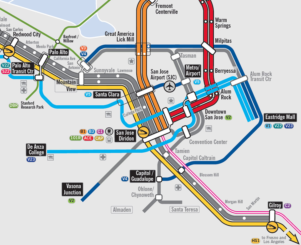
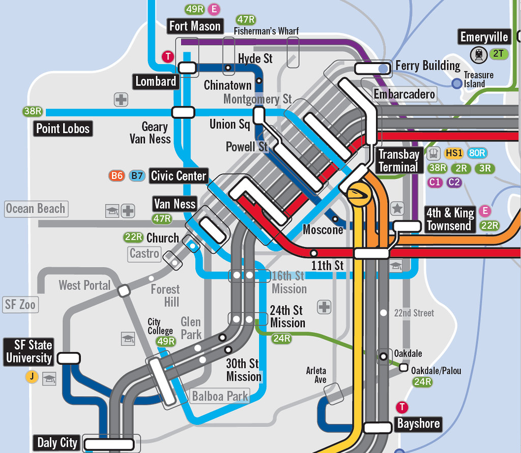
Note that the majority of the projects, routes, and modes reflect current Bay Area planning. However in some cases, the mode or route has been changed. In other instances, some new routes have been suggested. For example, BART to Livermore and Dumbarton Rail are two projects that are not included in this map. Instead, access to Livermore from BART is provided by bus rapid transit, and the Dumbarton corridor is served by rapid bus service. New projects that are not currently part of planning, or are in their early phases include projects like the Oakland Emeryville streetcar down Broadway, Capitol Corridor crossing at Vallejo, and 101 Rapid in the Peninsula.
The map shows all major rail, light rail, streetcars, and rapid bus lines. Each mode is differentiated by their line width. Colors vary to show each mode of transit. All rapid bus lines are marked in light green, BRT is light blue, metro commuter rail is orange, and metro subway is red. You can see these maps and some of my map photography at my flickr account.
If you would like to have a larger version of the map, which shows much more detail, send me an e-mail at brian.stokle@caa.columbia.edu.

Close Up of Oakland and Berkeley

Close Up of San Jose

Close Up of San Francisco

Close Up of Vallejo and the Carquinez Strait Area

Please feel free to comment. The maps are not meant as a definitive plan or my own opinion, but rather a discussion and debate point.
Note that the majority of the projects, routes, and modes reflect current Bay Area planning. However in some cases, the mode or route has been changed. In other instances, some new routes have been suggested. For example, BART to Livermore and Dumbarton Rail are two projects that are not included in this map. Instead, access to Livermore from BART is provided by bus rapid transit, and the Dumbarton corridor is served by rapid bus service. New projects that are not currently part of planning, or are in their early phases include projects like the Oakland Emeryville streetcar down Broadway, Capitol Corridor crossing at Vallejo, and 101 Rapid in the Peninsula.
The map shows all major rail, light rail, streetcars, and rapid bus lines. Each mode is differentiated by their line width. Colors vary to show each mode of transit. All rapid bus lines are marked in light green, BRT is light blue, metro commuter rail is orange, and metro subway is red. You can see these maps and some of my map photography at my flickr account.
If you would like to have a larger version of the map, which shows much more detail, send me an e-mail at brian.stokle@caa.columbia.edu.
Close Up of Oakland and Berkeley

Close Up of San Jose
Close Up of San Francisco
Close Up of Vallejo and the Carquinez Strait Area

Please feel free to comment. The maps are not meant as a definitive plan or my own opinion, but rather a discussion and debate point.

I like these maps, but they don't feel finished to me. The 29R doesn't show whether it hits Larkspur or San Rafael first after it leaves San Anselmo, and it's not listed on the key of services, while the difference between a gray and pink regional rail line isn't specified.
ReplyDeleteStill, as someone who is working
This is a pretty good start, but of course, there are little bits here and there that don't really fit, or other pieces that are really necessary. For example, for people living on the west side of SF, the #44 line from Glen Park BART-Forest Hill-Inner Sunset-GG Park-Inner Richmond could be upgraded to local rapid bus and really improve intracity and regional links (currently, the #44 is not too bad when it actually decides to come). This would serve many more residents and visitors than, say, what you've marked out as the "24R" local rapid bus, the route of which goes through areas that aren't actually populated (or popular), and not really in need of additional connections.
ReplyDeleteOf course, these are just nitpicks, it's the general end goal that counts.
Thank you for your comments. I always appreciate constructive feedback.
ReplyDeleteDavid E. - truth be told, you're right the 29R isn't in the legend listed with the other bus lines. You caught me - at the time the map was produced for SPUR, getting the basic map submitted by the deadline did mean there were a few parts not cross checked.
Regarding 29R, the map is intended as a basic map that shows where basic routes go. The 29R could easily be a route that only went from Fairfax, through San Rafael and onto the ferry terminal. Or it might only pass from Fairfax all the way along Sir Francis Drake through Ross and Kentfield or both. The idea was mostly to start a conversation and foster the idea of an east-west BRT or rapid line in central Marin County.
Brian. I agree it's a start. Regarding the idea of upgrading the 44 to a 44R, you may have something. I've taken the bus from Glen Park to the Richmond. It'd pretty quick, and was relatively full at 9 in the morning. I haven't heard of Muni proposing upgrading the line though, and I'm unfamiliar with its ridership levels, so that's why it wasn't included in the map.
The 24R was including to create a more viable link between Southwest SF (Bayview and Southwest Mission) and a BART station. Yes, we'd love to think the T-3rd is that link, but it's currently a slower than desirable route. As mentioned before, it was offered as a discussion point, much like a 44R would be.
I appreciate your thoughts. I'll be updating the map. You never know, version 2 may incorporate some comments. It may also include BART to the Richmond or something more ambitious. Stay tuned.
Sure. Just a quick note, for your 24R being a BART connection for Bayview: Check out where the current 44 goes after coming down the hill to Glen Park. It's a far quicker BART connection for Bayview (and Portola District, for that matter) than anything that would have to go to 24th and Mission.
ReplyDeleteAlso, this may sound a bit cynical, but if Muni doesn't propose doing something, that in itself might be a great reason to look into it. Example: I haven't seen a proposal from them to fix the design flaws in the doors on their streetcars, even though those things are perpetually broken and are a significant source of delays. Ride Muni for a long time, and it does that to you.
I don't understand why the VTA plans on connecting the people mover, for San Jose's airport, east to the Santa Clara Caltrain station and west to the First St. light rail line. They should build a single extension from the airport south to the Diridon station where passengers would be able to board light rail, Caltrain, ACE, and, in the future, high speed rail and BART. The line would be roughly the same length and it would cut through an undeveloped flood plain and industrial land. It would have to bore under I-880 but the current plans call for boring under a taxi way and two active runways.
ReplyDeleteSorry, that's west to Caltrain and east to First St. I've got many more thoughts about SJ's transportation planning if anyone is interested. Don't reply all at once, though. :)
DeleteI'm not sure either. Might be that a people mover or PRT from SC Caltrain to Airport to N. First Street would be about 1.6 miles long. A people mover from the Airport to Diridon would be 3 miles long. So from a mileage point, and presumably cost, the 1.6 miles is more desirable. That said, your point that the route to Diridon is not very hindered means that most of the route could be at grade or elevated, which would be MUCH CHEAPER than the tunnel required to go from Caltrain to First Street (assuming the route would be underground.) If they want a people mover above ground, it would be 3 miles as well.
DeleteFor the extra 1.4 miles you would get a direct link from the airport to a major surface transportation hub as well as San Jose's urban core. You could catch a Sharks game during a layover! As far as I can see, much of the alignment would be a combination of aerial structure and trenches with some tunneling but the underground portions could be cut and fill as opposed to the boring they would have to do beneath the runways to get to Caltrain. I imagine they're not putting much emphasis into the whole PRT project at this point since there isn't any funding. Also, the alignment you show was presented years ago when BART to SJ was just a pipe dream and HSR was nonexistent. I just hope they take another look at it when funding becomes available. SJC is so close to downtown that it could possibly one of the first PRTs to connect an airport to a downtown. BTW, thanks for the reply and I really enjoyed this piece you did on the possible future of Bay Area transportation.
ReplyDeleteI like these maps, but they don't feel finished to me. The 29R doesn't show whether it hits Larkspur or San Rafael first after it leaves San Anselmo, and it's not listed on the key of services, while the difference between a gray and pink regional rail line isn't specified.
ReplyDeleteStill, as someone who is workingBay Area Cable Railing