No Sea of Parking on the Waterfront
Over the past several months there's been a lot
of talk about San Francisco's waterfront - the waterfront along The Embarcadero
from Fisherman's Wharf down to Mission Bay. Much of the talk has been about
luxury housing, walls, arenas, protecting our city, and providing affordable housing. But
what do we actually have? a wide boulevard with a series of piers on the bay
side, and a mixture of short buildings and parking lots on the land side. Is all of this what protecting the waterfront is about?
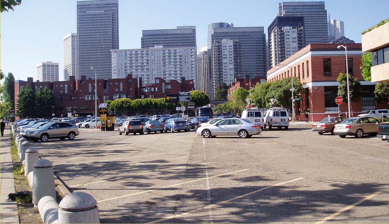 |
| Parking lot across from Exploratorium. "Wall" of Embarcadero Center and Golden Gateway (back). Image: SF Planning Department |
The June 2014 Proposition B (Prop B) calls for a citywide vote by the public if any development proposals on Port of San Francisco land should go over height limits zoned for this land. The height limits currently vary, but range from 40 feet (3-4 stories) north of Broadway, and up to 84 feet (6-8 stories) near the Ferry Building. Until now, the planning and approvals process for construction on the waterfront (and in most places) must go through a series of planning procedures, including public input, planning commission approval and sometimes board approval and eventually permitting.
Proponents of San Francisco Proposition B and the earlier Prop B that halted the 8 Washington St development, are saying we should protect the waterfront and stop a "wall on the waterfront". "Let the voters protect the waterfront", by letting them decide if a development would be allowed to go above current height limits. As quoted in their flyer (that I received in the mail):
"Prop B requires voter approval before building height limits can be raised on San Francisco's publicly-owned waterfront. It gives voters, not just developers, a voice on the waterfront that belongs to all of us." - Kate Lobby, Sierra Club
(Emphasis added)
Sounds compelling. Who wants a wall on a lovely waterfront? Why would requiring a city-wide vote on height limits be a bad thing? However, thinking critically and asking more questions I reflect: I didn't realize that the waterfront was governed by an oligarchy of developers. I thought, and know, that the waterfront land use and regulations are governed by the Port of San Francisco and by the San Francisco Board of Supervisors.
 |
| Image: SF Planning Department |
1. What exactly is the "waterfront"?
2. What's at the waterfront today?
3. What are we trying to protect?
4. What do we want our waterfront to look like?
Defining the Waterfront
Answering this question is easy. Although the
waterfront, and the area covered in Prop B covers the shoreline from
Fisherman's Wharf down to Hunters Point, for the sake of argument here we'll
consider the "waterfront" to follow Embarcadero (street) from King
Street near AT&T Park in the south to Jefferson Street in Fisherman's Wharf
in the north. The waterfront zone consists of all the water and land from the
bayside edges of the piers to 1-2 blocks landward of the Embarcadero. Most of
this land is owned and under the jurisdiction of the Port of San Francisco.
Today's Waterfront Development and Uses
Stepping back for a moment into history, let's remember that the waterfront was a much less desired place to spend your time recreating prior to the 1990s, and especially prior to the 1960s. Reason being it was an active port with many warehouses, the Belt Line Railroad running through the middle of Embarcadero, and the double-decker Embarcadero Freeway looming overhead.
The water/bay side uses of the waterfront have changed dramatically in the 22 years since the Embarcadero Freeway was removed. The Ferry Building has blossomed, the Exploratorium just opened, and even the shopping pier, Pier 39, added vitality to the waterfront.
However, the land-side uses are virtually identical to what they were 30 years ago in the 1980s! So why no change? I honestly don't know why. One thought is that it's not worth buying or leasing a super expensive property that can only go up 3 stories and be built as a boring office building away from where most offices want to be.
 |
| Image: San Francisco Public Library |
 |
| Image: San Francisco Public Library |
However, the land-side uses are virtually identical to what they were 30 years ago in the 1980s! So why no change? I honestly don't know why. One thought is that it's not worth buying or leasing a super expensive property that can only go up 3 stories and be built as a boring office building away from where most offices want to be.
 |
| Image: SF Planning Department |
- Fisherman's
Wharf shops and hotels, ranging from 2-4 stories (40’ limit)
- Embarcadero
offices, parking lots, and parks at offices (40-84’ limit)
- Financial
District parks, towers, and historic 8-story buildings (65-300’ limit)
- South
Beach parking lots and low rise buildings (45-105’ limit)
- Ballpark, park and marina (0-105’ limit)
Bayside
Historic piers with water views between. Some
piers are pedestrian only and offer great views of the bay and the city if you
look back.
Nice wide Herb Caen Way for pedestrians and people on bikes.
Pier uses vary, but there is a mix of
restaurants, offices, museums, the new Cruise Ship Terminal, and ultimately a
shopping mall in at Pier 39 with historic looking wooden architecture.
Boulevard
4-6 lane boulevard
Palm tree-lined median with streetcar tracks and
periodic stations
Bike lanes painted in - but not protected
Street parking
Landside
Office parks buffered by landscaped berms,
private tennis courts, public private spaces acting as parks and several huge
parking lots.
(Images below: Apple Maps)


(Images below: Apple Maps)
Views
Views vary as you walk along the Embarcadero.
Looking towards the bay, views are more limited than you would imagine. Every
pier blocks the view of the Bay while walking down the street. Luckily many of
the piers have lovely Art Deco entrance facades that make them look very nice.
With activated uses, the “view” is pleasant.
Looking towards the city, however, there are
ample views due to the propensity of parks and parking lots. As you walk north
from the Ferry Building you can see Coit Tower almost the entire walk up to
Fisherman's Wharf. Likewise, walking south, you can see the downtown skyline
including the Transamerica Pyramid and the Bank of America Building. However,
the Embarcadero Center acts as wall with its 4 long and very tall buildings, blocking
off the view of the rest of Downtown. Even the short 3-4 story office buildings
block nearly all views while walking on the west side of the street.
What's worth protecting?
- Views
of bay (between piers)
- Views
of landmarks and key view corridors
- Views
of Coit Tower
- Some
views of Downtown (including the Transamerica Pyramid)
- Historically important buildings
 |
| Image: Google Streetview |
What’s NOT worth protecting?
· Parking Lots
· Tennis Courts
· Boring suburban style
3-story office buildings with no active use facing the street.
Interestingly, the San Francisco Planning Department's Northeast Embarcadero Study looked at the same area and found the study area characterized by the following:
- Disconnected and dislocated public realm
- Surface parking lots leave major gaps in the pedestrian network
- Suburban-style office parks turn their back to the street
- Podium parking garages deaden sidewalks
- Wide streets interrupt pedestrian movement
- OPPORTUNITIES
- The Embarcadero Promenade, the Ferry Building and Piers 1-5 are all moving the water-side toward a truly gracious public realm
- The land side of The Embarcadero has lagged behind
- Ensure an active, attractive streetscape that provides inviting sidewalks and respects context established by historic buildings
- Establish guidelines for site design, massing, articulation and quality materials for new development.
So we have a near great water-side waterfront, and a very crappy land-side waterfront. What do you think is worth protecting? Well the folks who say "no wall on the waterfront" want to protect the crappy part apparently. They couch it in saying, keep the existing height limits, but in fact they probably want no new development.
 |
| Image: Google Streetview |
4. What do we want our waterfront to look like?
Personally, a series of parking lots and low slung 1980s
office buildings that butt up on a narrow sidewalk are not what I’d consider a GREAT
WATERFRONT. I do consider the bayside walk to be pretty nice, but that side is
not what is under contention.
Reviewing the Northeast Embarcadero Study, I'd say that study proposes what I would want. I'd only add that I'd do a 1-2 combo to improve on it. Raise height limits somewhat, from 40 feet, up to 60-70 feet, but have critical view corridors maintained so that when you walk out of the Exploratorium, you can still see much of Telegraph Hill and Coit Tower. Likewise, as you drive south on The Embarcadero, a view of the Pyramid or the Downtown skyline should be kept at one or two locations.
So in a quick, wrap it up conclusion, let's not have the entire population of San Francisco decide what should and shouldn't be built on the Embarcadero. Let's have our careful, methodical, and public input process take it's course. Let's NOT HAVE moneybag residents and office folks decide what should and shouldn't be built in our city.
Finally, don't take my word for it that Prop B (version June 2014) is bad for San Francisco. Check out Markasauras' informed take on Prop B titled "The Unintended Effects of Direct Democracy: Say “no” to ballot box planning on Proposition B June 3rd.".
 |
| Image: SF Planning Dept |
So in a quick, wrap it up conclusion, let's not have the entire population of San Francisco decide what should and shouldn't be built on the Embarcadero. Let's have our careful, methodical, and public input process take it's course. Let's NOT HAVE moneybag residents and office folks decide what should and shouldn't be built in our city.
Finally, don't take my word for it that Prop B (version June 2014) is bad for San Francisco. Check out Markasauras' informed take on Prop B titled "The Unintended Effects of Direct Democracy: Say “no” to ballot box planning on Proposition B June 3rd.".


Vote Yes on B!
ReplyDeleteWow your research and observation is mostly SPOT ON!
ReplyDelete